Our team specializes in the application of GIS in Forestry, Land Use, Agriculture and Water sectors. We work on cloud-based Big Data platform for Modelling and Mapping of Urban water, Flood and River Management and provide precise Agriculture Solution using such platforms. We conduct 3D structural Modelling using SAR and LiDAR.

We have extensive experience in carrying out multi-temporal LULC analysis, change analysis, forest vegetation/ type and degradation mapping, and biodiversity assessment, using optical and SAR data. We also support capacity development in RS-GIS applications.

Services

Forest Mapping Solutions

We offer development of forest inventories and maps, along with outlining the drivers of forest degradation and interventions for restoration.

View Projects

Agriculture Solutions/ Agricultural Productivity and Cropping Pattern Analysis

We assist stakeholders in visualizing farmland productivity and monitoring crop health.

View Projects

Water Solutions/ Modelling for Water Management

Our GIS and RS solutions support improved water management and associated effective land use practices.

View Projects

Landscape Mapping Solutions

With the application of multiple spatio-temporal satellite images, we derive the current and historical LULC for development of baseline and inventory management.

View Projects

Forest Mapping Solutions

National Technical Assistance to Analyze Data and Design Best Practices During Updation of Forest Working Plan

IORA assisted the Assam Forest Department in updating 21 Working Plans in Assam as per National Working Plan Code (NWPC)-2014 using global best practices and latest technological approaches. We seamlessly integrated remote sensing analysis and GIS with the Working Plan designs and created robust datasets through; i)Use of advanced geo-spatial algorithms to map the green wash of the area; ii)Site suitability analysis and correlation of different attributes with suggestions site specific treatment; iii) Assessment, mapping and geo-spatial representation of the forest growing stock at compartment level (smallest forest management unit); iv) Creation of remote sensing based regression models for carbon stock estimation; and v) Spatial delineation of micro-watersheds. Additionally, a mobile app was developed which supports the real time entry of forest inventory data.

New transitions in smallholder agricultural systems that promote increased tree cover outside of forests (TOF)

IORA is working in collaboration with Michigan State University (MSU) and Forest Survey of India (FSI) to quantitatively examine the trend of increasing TOF and the processes that promote this trend in smallholder agriculture systems. The study will identify where and how natural ecosystem conversion and land degradation is being reversed in India. The project will examine farming processes that promote increase in TOF in smallholder agricultural systems. The study endeavours to integrate GIS analysis with econometric valuation of ecosystem services from TOF to ascertain if there is a correlation between increase in tree cover and high financial valuation of ES. This economic analysis will further help to determine the factors that are driving these trends.

Robust and Efficient Analysis Approaches of Remote Imagery for assessing Population and Forest Health in India

Addressing the problem of dealing with complex and high dimensional data, IORA is collaborating with The University of Cambridge under the Engineering and Physical Sciences Research Council (EPSRC) and Global Challenges Research Fund (GCRF) project to develop novel satellite image analysis and machine learning tools supporting health and environment modelling in India. The project will develop new algorithms to map tree species from India’s forests using air-borne hyperspectral imagery data made available through NASA and ISRO. This species-level mapping attempts to mark and identify the extent of plantation cover vs natural forests. It will facilitate improved decision making for effective & robust forest management with minimal loss in quality and biodiversity. Additionally, these activities will benefit the forest-dependent local communities and will help in mitigating climate change. The project is supported by an interdisciplinary project team of researchers and stakeholders from academia and industry, and therefore seeks to contribute to improved decision making in forest policies in India.

Agricultural Productivity and Cropping Pattern Analysis

Developing Sustainable Agriscapes for Future Phase 1, Phase 2 and Phase 3

IORA was awarded the Sustainable Agriscape for the Future, Phase I and Phase II led by IUCN-India. The programme aims to study agro-ecosystems, their biodiversity and trends of ecosystem services, in order to design suitable ecosystem-based interventions to promote crop productivity to ensure the sustainability of various ecosystems.
During Phase I of the programme, IORA has conducted baseline studies on assessment of Socio-economic, Biodiversity and Ecosystem services review, and spatial delineation of agriscape units based on mapping ecosystem services flow towards in agriculture in Munger landscape. In phase II of programme, IORA prepared a detailed project report on the agriscape plan on interventions for restoration and revival of ecosystem services in the pilot clusters viz; Asarganj, Kharagpur and Sadar. IORA also conducted a training need assessment and developed training modules on sustainable agriculture practices along with community based monitoring framework for activities implemented under the programme. In continuation to that, IORA is working towards the development of Sustainable Agriscapes in Ghod Basin in Maharashtra and Bhavani Basin in Tamil Nadu. Using our experience in Munger, we will delineate Agriscapes and suggest interventions in the current project areas. The work involves undertaking baseline surveys on ecological, biodiversity and ecosystem services of the landscape, spatial identification and removal of existing gaps and provision of suggestions on interventions supporting the rejuvenation and enhancement of ecosystem flows. The selected interventions will be geospatially designed with a unique identification code generated for piloting. These Agriscape Plans will further be validated through triangulation. Implementation for the project is expected to enhance biodiversity and flow of ecosystem services in the region. This will further enable food security and enhanced livelihoods for the project beneficiaries.

Analysis of Synergies and Trade–offs in the Water–Energy–Food Nexus: A Case Study on the Indo–Gangetic Plain (IGP)

IORA assisted Vertiver for IIT – Mumbai’s study on ‘Analysis of Synergies and Trade–offs in the Water–Energy–Food Nexus: A Case Study on the Indo–Gangetic Plain (IGP)’. We supported the project by creating an interactive web-based interface, which will allow the end-users to visualise and highlight the expected changes in Kcal production, diversity, water usage and farmer’s income under different interventions scenes. Basis the observations provided by IIT – Mumbai and Vertiver, we generated vector layers and hosted them on Geoserver. Additionally, we developed a basic user interface and added functionalities for efficient visualization of the GIS layers

Modelling for Water Management

Preparing Decision Support Tool -Region and Context Dependent Afforestation for Water Conservation and Run – off Avoidance

As part of our afforestation programmes, we developed a regional Decision Support Tool (DST) for the Maharashtra Forest Department to help create positive impacts on water conservation and runoff avoidance. IORA finalised the decision support system parameters and projected the analysed data in the spatial domain. We also created GIS layers in the spatial domain which constituted forest type, forest cover, LULC, soil, temperature, rainfall, hydrological and geological information. These layers were used for the development of digital species centric afforestation plans for water conservation in the area under study.
IORA also designed an Afforestation Decision Support System (ADSS) by developing a web-enabled portal (WEP) hosting the GIS layer and a database to answer queries for both android and iPhone systems.

Development of Meghna Basin Land Use and Water Resources Atlas

Commissioned by IUCN – Bangkok, we developed an online Land Use and Water Resources Atlas, comprising of illustrative thematic maps, infographics, and land parcel information for Meghna Basin. This altas will be hosted on a publicly accessible cloud for easy/ uniform interaction with the basin map data with the option to add future land datasets. The platform will provide an opportunity for the stakeholders/ land use managers to effectively manage their land resources in a dynamic environment.

Agricultural Productivity and Cropping Pattern Analysis

Developing Sustainable Agriscapes for Future Phase 1, Phase 2 and Phase 3

IORA was awarded the Sustainable Agriscape for the Future, Phase I and Phase II led by IUCN-India. The programme aims to study agro-ecosystems, their biodiversity and trends of ecosystem services, in order to design suitable ecosystem-based interventions to promote crop productivity to ensure the sustainability of various ecosystems.
During Phase I of the programme, IORA has conducted baseline studies on assessment of Socio-economic, Biodiversity and Ecosystem services review, and spatial delineation of agriscape units based on mapping ecosystem services flow towards in agriculture in Munger landscape. In phase II of programme, IORA prepared a detailed project report on the agriscape plan on interventions for restoration and revival of ecosystem services in the pilot clusters viz; Asarganj, Kharagpur and Sadar. IORA also conducted a training need assessment and developed training modules on sustainable agriculture practices along with community based monitoring framework for activities implemented under the programme. In continuation to that, IORA is working towards the development of Sustainable Agriscapes in Ghod Basin in Maharashtra and Bhavani Basin in Tamil Nadu. Using our experience in Munger, we will delineate Agriscapes and suggest interventions in the current project areas. The work involves undertaking baseline surveys on ecological, biodiversity and ecosystem services of the landscape, spatial identification and removal of existing gaps and provision of suggestions on interventions supporting the rejuvenation and enhancement of ecosystem flows. The selected interventions will be geospatially designed with a unique identification code generated for piloting. These Agriscape Plans will further be validated through triangulation. Implementation for the project is expected to enhance biodiversity and flow of ecosystem services in the region. This will further enable food security and enhanced livelihoods for the project beneficiaries.
Analysis of Synergies and Trade–offs in the Water–Energy–Food Nexus: A Case Study on the Indo–Gangetic Plain (IGP)

IORA assisted Vertiver for IIT – Mumbai’s study on ‘Analysis of Synergies and Trade–offs in the Water–Energy–Food Nexus: A Case Study on the Indo–Gangetic Plain (IGP)’. We supported the project by creating an interactive web-based interface, which will allow the end-users to visualise and highlight the expected changes in Kcal production, diversity, water usage and farmer’s income under different interventions scenes. Basis the observations provided by IIT – Mumbai and Vertiver, we generated vector layers and hosted them on Geoserver. Additionally, we developed a basic user interface and added functionalities for efficient visualization of the GIS layers

Landscape Mapping Solutions

Estimation of Potential Value of Ecosystem Services and Development of REDD+ Project for Assam

IORA developed a pilot Jurisdictional REDD+ project in Assam with an aim to leverage additional national and international financing towards enabling successful integration of multiple sustainable forest management interventions with emphasis on income generation and livelihood security. It involves Land Use and Land Cover analyses to develop a REDD+ baseline, setting up an interdepartmental REDD+ Cell and a departmental REDD+ Task Force in the State. We developed a monitoring plan for the project and trained forest department personnel on REDD+ activities.

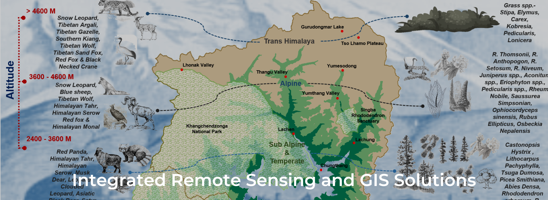
Preparation of land use maps, vegetation cover; and biodiversity status report of landscapes in selected districts of Sikkim (Upper Teesta – Khangchendzonga Landscape)

Building on the GEF-funded SECURE Himalaya project, IORA worked on the “Preparation of land use maps, vegetation cover and biodiversity status report for Upper Teesta – Khangchendzonga Landscape, Sikkim”.
Under the project, IORA was engaged in discerning and prioritising regions with varying biodiversity. It analysed the relationship between regional biodiversity and existing land use. The study entailed detailed explanations on the use of high-resolution spatial and non-spatial datasets. These explanations guide how these datasets can delineate land use and land cover of the entire landscape and the areas administered as per the various socio-legal rights including reserved forests, protected areas, natural and anthropogenic habitats.
We also conducted socio-economic surveys and focused group discussions (FGD) in the region to quantify the economic value of floral biodiversity and overall land use by the local communities. Cost-effective and implementable recommendations that may aid in monitoring the health of the landscape, were also shared.

Preparation of Temporal change detection & LU/LC mapping of Talabira-I Coalmine based on High-Resolution Satellite Data for the year 2015 & 2018

IORA supported Raipur Energen Limited (REL) under a project study to assess the temporal LU/LC change analysis mapping of Talabira-I Coalmine (for the year 2015 and 2018) using geospatial technology. We also conducted change detection analysis of spatio-temporal changes in land-use patterns which aligned with 10km buffer from Talabira-I Coalmine area. These mapping outputs were further shown in different scales (1:5,000 and 1:25, 000) using advance cartographic designed tools and statistical analysis charts & tables.

Capacity Building and developing Land Use and Land Cover Maps for 400 villages to support the implementation of Meghalaya led Land Scape Management Project (MCLLMP) under MBMA

Aspiring to restore the degraded landscapes, build climate resilience and generate livelihood opportunities in the state, Meghalaya Basin Management Agency (MBMA) is implementing a 5-year (2018-2023) Meghalaya Community Led Landscape Management Project (MCLLMP) supported by the state government and the World Bank. The project focusses on systematically strengthening the planning and management of natural resources in the state using techniques that support and strengthen the traditional community led landscape management approach with appropriate scientific technology and financial mechanisms. The proposed NRM interventions will be implemented across 400 villages using a decentralised and participatory approach. IORA is assisting MBMA in generating several accurate thematic baseline datasets using high resolution RESOURCESAT-1/2, LISS IV (5m) satellite images. We are designing the temporal Land Use Land Cover (LULC), vegetation indices and carbon stock maps to assist the local communities to visualise the land use and to understand the status of natural resources in the landscape. This will further assist the communities and other local staff to prepare their own integrated NRM plans (resource mapping, data collection, land use planning, project design and monitoring). We will focus on building capacity of stakeholders, by training them on application of geospatial science in land use mapping and monitoring of natural resources. The project endeavours to integrate the concepts of traditional community driven landscape management approach with spatial science to enable the development of a scientific and effective NRM plan.

Feasibility Study for Conservation of Ecologically Sensitive Dodamarg Biodiversity Corridor Region

Dodamarg is an Ecologically Sensitive Area (ESA), part of the Western Ghats (a biodiversity hotspot) and a wildlife corridor. This study aimed to prioritize financial mechanisms for conservation activities in the area, like REDD+ feasibility to reduce the pressure generated from various drivers of deforestation. IORA generated a Land use/cover change matrix by analysing the Landsat satellite data from 2005 to 2015. The satellite datasets were classified using a hybrid approach. IORA used both leaf on and leaf off datasets to delineate the forest cover. Total area under study was 1350.21 square kilometres.

Assessing the impacts of Invasive Species on Forest Eco-system in the State of Sikkim

IORA prepared a report on invasive plant species in Sikkim and prepared an action plan for their management in the context of climate change using high resolution remote sensing data and mapping technologies. The mapping was conducted using high resolution images of World View II , mapping algorithms and field information. Several algorithms were tested to delineate area under invasives. Data driven modelling improvised the mapping accuracy which was verified through ground truthing. Out of several species that were mapped, Lantana camara, Eupatorium and Ageratum conyzoides were identified as invasives. IORA also developed an action plan to assist the State Nodal Institutions on climate change and the implementation of the State Action Plan on Climate Change (SAPCC). IORA provided effective management strategies for invasive species and conducted dissemination workshop with officials from forest department.

Preparation of “Brief Document” on Wetlands of Sikkim State

Forest, Environment and Wildlife Management Department, Government of Sikkim engaged IORA to prepare a Brief Document on Wetlands of Sikkim. The document will facilitate implementation of Wetlands (Conservation and Management) Rules, 2017. This is a first-of-its kind field-based assessment of high altitude wetlands. We prepared a comprehensive digital inventory of all wetlands in Sikkim, including clear demarcation of boundaries supported by accurate digital maps, demarcation of their zone of influence and land use and land cover thereof, biodiversity elements, description of ecological characters and account of pre-existing rights & privileges. We further identified wetlands which require critical intervention. We also developed a comprehensive list of activities to be regulated and permitted within the notified wetland area in addition to modalities for the enforcement of regulations.

Home
Our Work
Key Project
News